28. Atmospheric River Quilt / Tryon Creek Hike 10/22/2107

Heavy rain predicted for the weekend. Meteorologists describe an atmospheric river headed our way. Hiking questionable. Time for some quilting!

I have finally drawn a successful template for my giant clamshell quilt, and spent some enjoyable moments sorting fabric for the clams. It began with a stack that I purchased approximately 20 years ago at a quilt shop in Bend, Oregon – blue-green-purple with gold metallic accents in geometric patterns.

DSC09521

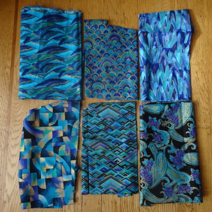
I have used small pieces in scrap quilts, but have been more recently plotting to use these in a giant clam shell quilt, inspired by one I saw on a bed at the Metolius River Lodge in August of 2012.  That one had 19 1/2″ wide clams.


The dimensions of my available stash limit my clam size to 18 inches maximum. It took me a while to design the clam shell template. I resorted to creating a compass with a piece of graph paper, a pin, and a mechanical pencil.  I traced the half-clam onto freezer paper, and will use the freezer paper template to cut 40 whole clams on the fold, and 20 different half clams, 5 each left, right, top and bottom.  I watched the Latifah Saafir YouTube video on sewing clams without pins, but I have already made drunkard path, apple core and half-circle quilts, so I am familiar with the technique.  These curves will be relatively easy to sew, I hope, with such large circles.

DSC09419

I visually selected a palette of cool colors to go with the focus fabrics. It makes me happy that I can make this a charm quilt in the sense that each fabric is used only once. After cutting the large clams from my larger fabrics, I placed the smaller pieces around the tentative layout to audition for the half clams.


As I looked at the flood of cool, watery colors on the floor, the perfect name popped into mind – Atmospheric River. In the week ahead I plan to finish cutting the half clams and finalize the layout. Then, on to the sewing.

Tryon Creek Hike  10/22/2017   (#51)

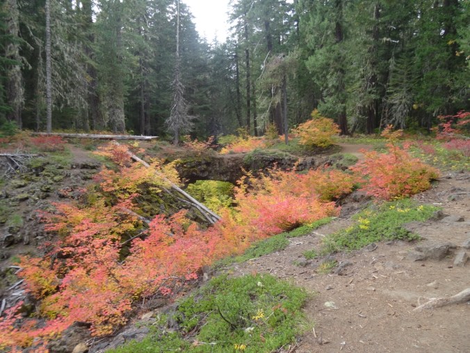
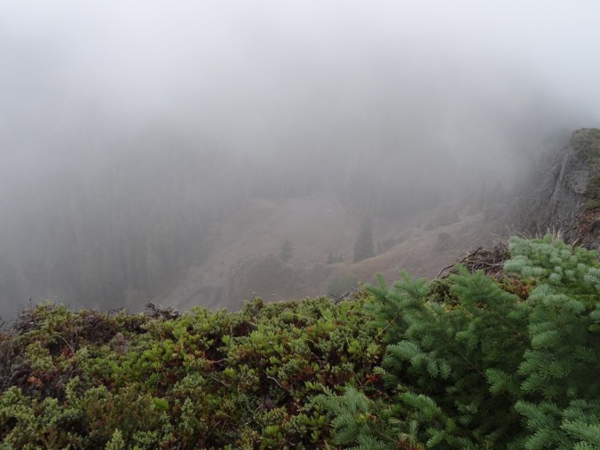
Meanwhile, by Sunday afternoon, the atmospheric river had passed over our area, and we headed to Tryon Creek State Park, only 20 minutes away, for a brief hike in the drippy forest.  This beautifully maintained park is one of the oases of nature surrounding Portland. A maze of trails and bridges cross and recross Tryon Creek, providing peaceful moments.

Big leaf and vine maples showing fall color:


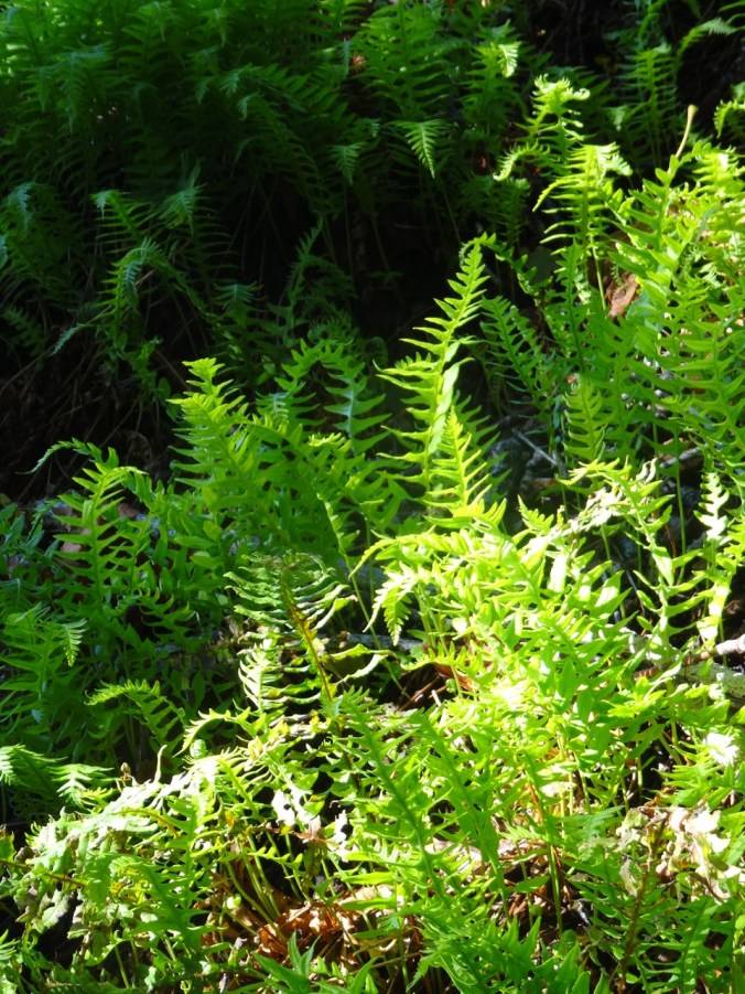
Moss, fern and cedar:


Muddy creek reflections:


About 3 miles/300 feet.

Screen Shot 2017-10-22 at 8.31.01 PM

LOOKBACK:

We have hiked in Tryon Creek many times – it is famous for blooming Trillium in the spring.

DSC00503

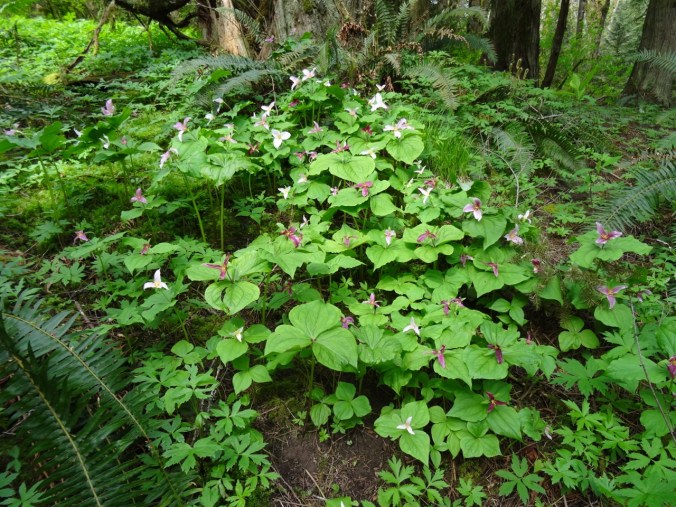
Trillium at Tryon Creek, April 2015

OTHER CRAFTING:

Kimono robe and socks I made for my daughter for her birthday.


27. Cape Horn Loop, Columbia River Gorge, Washington

Cape Horn Loop     October 14, 2017    (#50 – hikes in 2017)

On a beautiful fall day, after several days of rain, we went with friends to the Cape Horn trail just east of Washougal, WA.  This view shows the massive cliffs of Cape Horn from Angel’s Rest on the Oregon side of the river. Our trail will follow the road down to the lower green fields, then traverse west along the lower cliffs before heading back up hill to the top of the mountain.

DSC01098

October 2014  Cape Horn viewed from Angel’s Rest

Fog draped the summit when we arrived, so we chose to hike clockwise around the loop, our first views being the highway 14 viaduct above us as we completed the road walk.

DSC09343

From the road, the trail then enters the forest, and emerges onto the open mossy scree slopes above the cliffs adjacent to the waterfall (which was at very low flow).

DSC09352DSC09360DSC09357

We reached the lowest part of the trail above the Columbia River, and could look east to see Cigar Rock.

DSC09363

DSC09365

Eastward view toward Beacon Rock, Phoca Rock; fog topped cliffs

We continued across the cliffs, and opted for the westernmost loop that leads onto a promontory above the western entrance to the train tunnel that cuts through the cliff beneath us.

DSC09368

From here, the trail heads upward through various switchback sections, with spurs to the Oak and Waterfall viewpoints, then through the trail tunnel under highway 14, and finally up to the Nancy Russell Overlook, where plenty of other hikers were resting.

DSC09394DSC09392

We saw two giant baguettes being transported by barge (or was it sawdust)?


DSC09388

There is a distinct sandbar in the river channel below glinting in the sun.

DSC09381DSC09379DSC09378

Next, the traverse along property boundaries to the actual highest point – Pioneer viewpoint. By this time the fog had evaporated.

DSC09396

View to the east upriver from Pioneer Point

DSC09395

View to west from Pioneer Point, including Hwy 14 viaduct

From there it is all downhill, down the steep switchbacks to the trailhead.  We were a bit early for the fall color display, and saw only one flower, a penstemon, whereas in the spring the trail is lined by hanging gardens of wildflowers.

It was a lovely day for a hike. On a side note, the turftoe plate I was using in my right boot seemed to delay the onset of pain in my arthritic big toe for a couple of miles, and I hope this tool will allow me to continue with longer hikes.

Screen Shot 2017-10-14 at 6.28.32 PM

Total for the day: 7.5 miles, 1350 feet.

Look back:

We have hiked this trail several times – though we have only completed the full loop a couple of times because the lower cliff area is closed from February to July for peregrine falcon nesting. In 2014, when we hiked the lower loop, we saw a train exit the tunnel beneath us.


DSC01368

The most striking comparison is the new view of burned up Angel’s Rest, almost directly across from Cape Horn on the Oregon side of the river.  Green in the past, it is now brown.

DSC04450

Angel’s Rest 2014

DSC09394

Angel’s Rest 2017

Crafting:

I have knit two more tortillas and a square purple wash cloth, as well as mended four pairs of hand knit socks in time for winter.

I have been planning my giant clam shell quilt, but have not yet made a satisfactory template.  More on that later.

DSC09340

26. The Perfect Fall Hike on Mt Hood

Mirror Lake and Tom, Dick & Harry Mountain, Mt. Hood     October 6, 2017    (#49)

Screen Shot 2017-10-06 at 8.33.54 PM

Sunny skies, shady forest, bright red huckleberry and vine maple on the scree slopes, reflections of Mt Hood in Mirror Lake, five cascade volcanoes in view at the top. Total distance 6.6 miles, 1500 feet.


DSC09255

Mt St Helens, Mt Rainier and Mt Adams to the north

DSC09261

Mt Jefferson to the south


Lookback:

We have hiked here in every season, including with micro spikes on on New Years Day 2014, a low snow year; and a failed snowshoe attempt in January of 2016, when the snow above the lake was too deep to find a safe trail.  Spring and summer flowers, brilliant fall color, fabulous views when not cloudy.  The trail is overly popular for good reason.

Comparison photos: 

Views from Mirror Lake to Mt. Hood:

IMG_8223

September 27, 2010

DSC09993

January 1, 2014

DSC00011

January 8, 2016

DSC00176

November 4, 2016

DSC09303

October 6, 2017

Views to Mt Hood from the top of Tom Dick and Harry Mtn:

IMG_8210

September 27, 2010

DSC03502

June 1, 2013

DSC00029

January 1, 2014

DSC00203

November 4, 2016

IMG_0044

October 6, 2017

25. Early Fall in the Gifford Pinchot

September 30, 2017    Rainy weekend predicted; possible dry window Saturday to the east of Portland;  Indian Heaven still closed from the Crater Fire; windy along the Columbia River. We decided to try some short hikes in the Gifford Pinchot National Forest between Mt Adams and Indian Heaven, near Trout Lake, WA.

IMG_0036

Our first drive through the Columbia River Gorge since the fire: Good photos are posted in official feeds elsewhere.  I was pleased to see how much is not burned. That said, it was sobering to see the extent of the burn: blackened trees on the skyline, blackened forest floors down to the highway in some places, blackened trunks on still green trees.  I felt great appreciation for the fire fighting, for the massive cleanup that has already occurred, and for the challenge ahead. We will be back someday but not soon.

DSC09082

Through the passenger window of a moving car:  Blackened trees on the skyline; slash piles below.

We got a glimpse of Mt Adams and an intense, wide rainbow just as we entered Trout Lake.


Steamboat Mountain  (#48)

This short hike (1.5 miles, 400′) is touted by Scott Cook in his Curious Gorge book to have some of the best views of the Cascades and a relatively easy trail. The weather was not in our favor, though.  When we parked at the trailhead/quarry, we could just see the top of Steamboat Mountain from the base.


As we hiked up the well graded trail through red huckleberry the clouds closed in.


From the rocky top, I could just make out our Suburu parked at the base, but no mountains, no views.

DSC09103

Looking down at our Suburu (center of photo) from the top


We ate our lunch, hiked down.  We were reminded that we are now in hunting season, as people were firing guns just on the other side of the quarry.

Langfield  Falls

Driving back south toward Trout Lake, we visited Langfield Falls, just east of Tire Junction.  There is a short trail down to the waterfall viewpoint, and another user trail along the creek above the falls. A spatter of rain, a lovely waterfall.


Natural Bridge

Back to Trout Lake, then west about 5 miles, is the Natural Bridge area- a collapsed lava tube with bridges in places of incomplete collapse.  A friend from the Portland Hikers Facebook group had tipped us off to brilliant fall color here, and we found this to be true – even if we were early for the full show.  The inner collapsed tube is overgrown with vine maples that blazed in gradation through the spectrum from bright green, to yellow green, yellow, yellow orange, orange, red orange and red: the analogous colors from half the color wheel on view.  We wandered around for a while, and Dan set up his tripod as we waited for sunbreaks to illuminate the scene.

DSC09140

One of the Natural Bridges


DSC09182

Dan with tripod