25. Early Fall in the Gifford Pinchot

September 30, 2017    Rainy weekend predicted; possible dry window Saturday to the east of Portland;  Indian Heaven still closed from the Crater Fire; windy along the Columbia River. We decided to try some short hikes in the Gifford Pinchot National Forest between Mt Adams and Indian Heaven, near Trout Lake, WA.

IMG_0036

Our first drive through the Columbia River Gorge since the fire: Good photos are posted in official feeds elsewhere.  I was pleased to see how much is not burned. That said, it was sobering to see the extent of the burn: blackened trees on the skyline, blackened forest floors down to the highway in some places, blackened trunks on still green trees.  I felt great appreciation for the fire fighting, for the massive cleanup that has already occurred, and for the challenge ahead. We will be back someday but not soon.

DSC09082

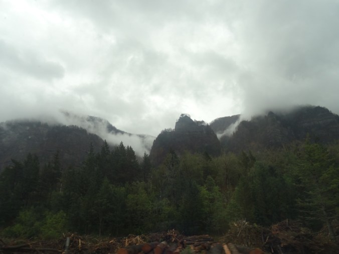
Through the passenger window of a moving car:  Blackened trees on the skyline; slash piles below.

We got a glimpse of Mt Adams and an intense, wide rainbow just as we entered Trout Lake.


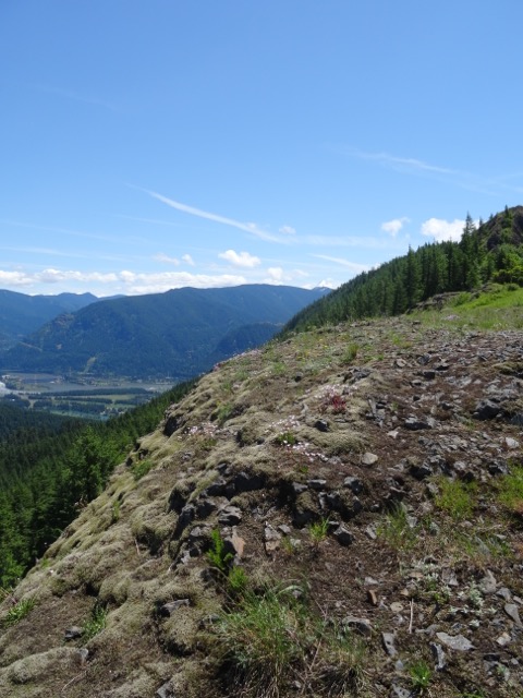
Steamboat Mountain  (#48)

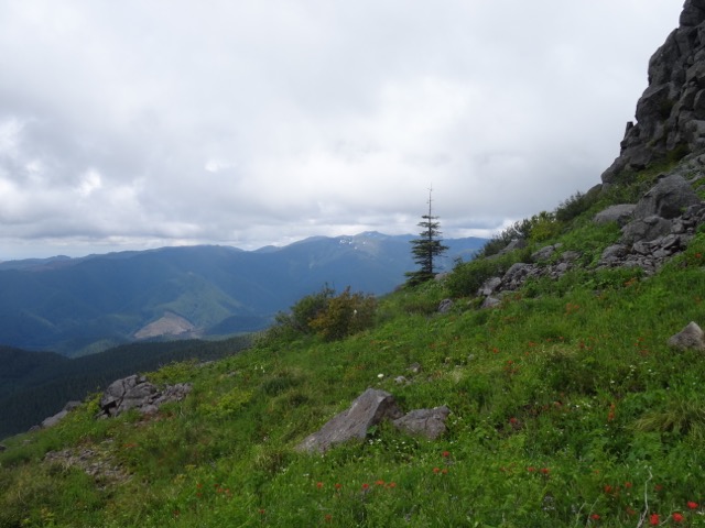
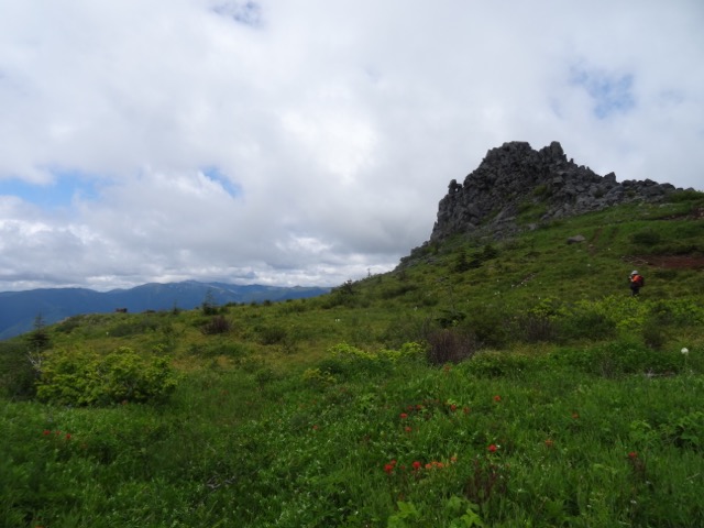
This short hike (1.5 miles, 400′) is touted by Scott Cook in his Curious Gorge book to have some of the best views of the Cascades and a relatively easy trail. The weather was not in our favor, though.  When we parked at the trailhead/quarry, we could just see the top of Steamboat Mountain from the base.


As we hiked up the well graded trail through red huckleberry the clouds closed in.


From the rocky top, I could just make out our Suburu parked at the base, but no mountains, no views.

DSC09103

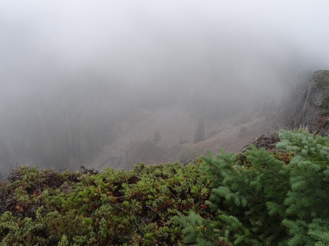
Looking down at our Suburu (center of photo) from the top


We ate our lunch, hiked down.  We were reminded that we are now in hunting season, as people were firing guns just on the other side of the quarry.
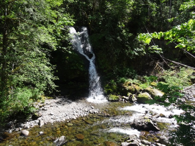
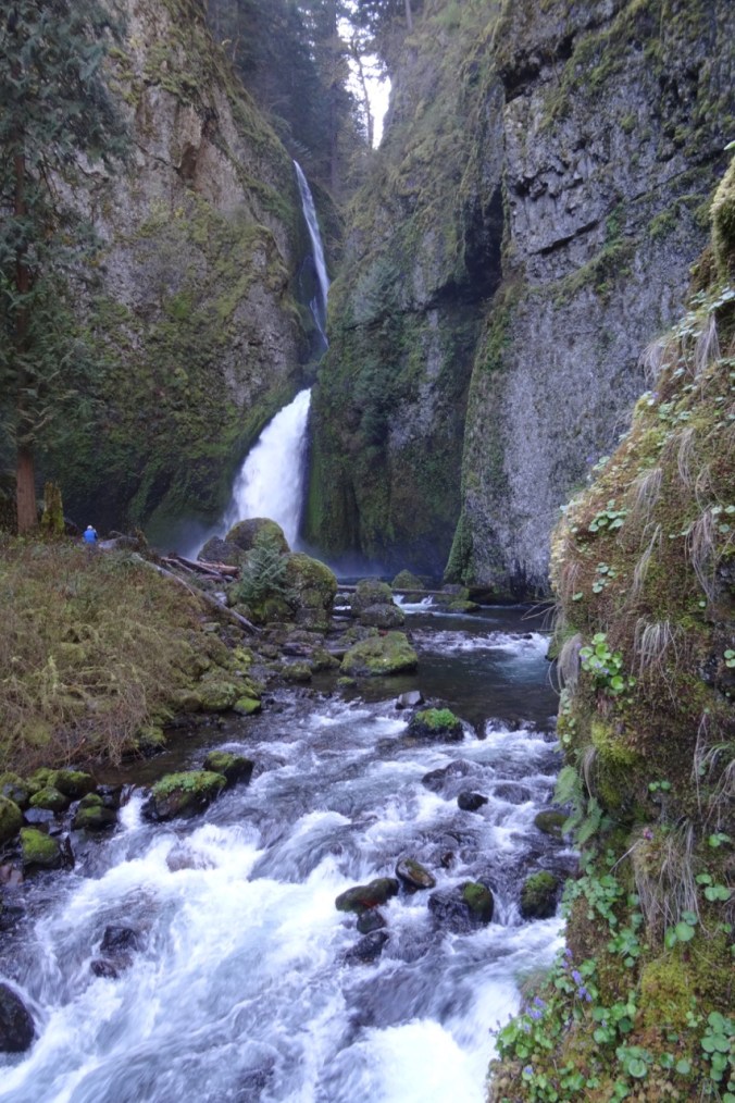
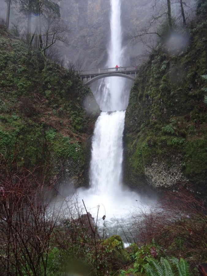
Langfield  Falls

Driving back south toward Trout Lake, we visited Langfield Falls, just east of Tire Junction.  There is a short trail down to the waterfall viewpoint, and another user trail along the creek above the falls. A spatter of rain, a lovely waterfall.


Natural Bridge

Back to Trout Lake, then west about 5 miles, is the Natural Bridge area- a collapsed lava tube with bridges in places of incomplete collapse.  A friend from the Portland Hikers Facebook group had tipped us off to brilliant fall color here, and we found this to be true – even if we were early for the full show.  The inner collapsed tube is overgrown with vine maples that blazed in gradation through the spectrum from bright green, to yellow green, yellow, yellow orange, orange, red orange and red: the analogous colors from half the color wheel on view.  We wandered around for a while, and Dan set up his tripod as we waited for sunbreaks to illuminate the scene.

DSC09140

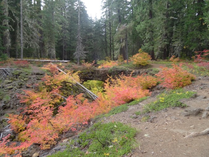
One of the Natural Bridges


DSC09182

Dan with tripod

22. Mt St Helens Boundary Trail

Eagle Creek fire update as of  9/11/17:  34000 acres, 7% contained.

21640885_123414854982697_7881458328682540061_o

USFS Incident Map

Boundary Trail toward Harry’s Ridge     9/10/2017    (#45)

The skies are alternating blue and cloudy today. Unsure of any firesafe place east of us, we opted to drive north to Johnston Ridge, Mt St Helens National Monument.  Clouds that were floating at mountain level when we arrived late morning evaporated during the day.

DSC07837DSC07842

DSC07848

Mt St Helens

We hiked the Boundary Trail toward Harry’s Ridge.

DSC07855

Coldwater Peak, north of the Boundary Trail

The trail that used to go along a steep, cliffy slope to the grand viewpoint at Devil’s Elbow is now closed.  The new alternate route cuts over the ridge, and has a view to Spirit Lake from the pass at the top of the cutoff. We stopped there for lunch.

DSC07851

Lunch stop at the top of the new cut off trail, with view to Spirit Lake

I decided it was too hot to continue, so hiked slowly back to the observatory.  Dan went on to Harry’s Ridge then met me back at the observatory later.  I had the chance to watch the excellent 16 minute film that simulates the eruption and illustrates the forces of nature during the 1980 eruption.

DSC07861

View while hiking back toward Johnston Observatory

DSC07871

Looking east from the observatory toward Mt Adams

DSC07872

Mt Adams

There are straggling summer flowers in bloom – lupine of both large and dwarf varieties, penstemon, paintbrush, yarrow, an abundant yellow composite, and equally abundant white pearly everlasting gilding the slopes, and standing out strongly in contrast to the early reds of fall.

We stopped at Coldwater Lake to walk the boardwalk trail that illustrates the Birth of the Lake. It was peaceful and beautiful there, with excellent views of Minnie Peak and Mt St. Helens. It is pleasant to walk through shady foliage after spending time in the blast zone. My total mileage for the day was about 5 miles/800 feet.

LOOKBACK:

Boundary Trail to Harry’s Ridge – we have hiked this trail in several seasons, with different views of the mountain:

DSC05594

June 2016

DSC07868

September 2017

DSC05602

Inner crater dome close up    June 2016

DSC07849

September 2017

Coldwater Lake:

In March of 2015, a low snow year, we walked the 12 mile loop around Coldwater Lake.  The foliage was mostly dormant and brown.  We had views of the mountain, walked by the abandoned logging machinery destroyed by the blast, got some closer views of Minnie Peak.

DSC03346

March 2015   Minnie Peak and old logging machinery on Coldwater Ridge

DSC03371

March 2015    Minnie Peak


DSC03460

March 2015

DSC07882

September 2017 Mt St Helens and Coldwater Lake

In Spring of 2017 we were in the area hiking the Hummocks trail, and we visited the Science and Learning Center, which gave us a snowy view of the boardwalk that we walked on today.

DSC01570

February 2017   Looking down on Coldwater Lake


20. The Columbia River Gorge is on fire!!!

September 5, 2017

In northeast Portland the sun is cloaked in an orange shroud, the air tastes bitter, smells like smoke, and is dripping ash, ash from the burning trees in our beloved Columbia River Gorge!  The heat has pushed the human caused (allegedly a teenager with firecracker) conflagration west along the famous waterfall corridor.  Residents have evacuated and their homes are intact so far. Firefighters are working hard, may they stay safe!  But the weather is so hot and dry and the winds relentless – we all fear for the next stage of this tragedy.  It is a waiting game now as I reflect on all the lovely hikes we have taken in the area – waiting to know which of these amazing places are intact, and which will begin a new phase of regrowth and regeneration.  I am no stranger to hiking in burn zones, but this particular area was so lush and green.  It is very sad.

From east to west, some of our favorite places that are threatened or burned:

Herman Creek

 Dry Creek Falls

DryCreekFalls

Dry Creek Falls April 2017

Eagle Creek

Note that steep trail area is likely where the fireworks were used.

Wahclella Falls

WahclellaFalls

Wahclella Falls April 2016

McCord Creek / Elowah Falls

Oneonta / Horsetail area

Wahkeena / Multnomah Falls Loop

Multnomah Falls

MultnomahFalls

June 2014

MultnomahFalls (2)

December 2015

MultnomahFalls (3)

November 2014

Angel’s Rest

Latourell Falls

Views from Washington toward Oregon where the fire is burning

HamiltonMtn

Hamilton Mountain, looking toward Bonneville Dam May 2016

CapeHorn

Cape Horn looking upriver April 2016


13. Latourell Falls and Sherrard Point, 7/14/2017

Latourell Falls and Sherrard Point  7/14/2017  (#37)

Health issues and visitors slowed down my hiking this past couple of weeks, but we ventured out again to the Oregon side of the Columbia River Gorge, with our visiting son, to an easy waterfall hike and an iconic viewpoint.

 Latourell Falls

Latourell Falls is one of the westernmost waterfalls in waterfall alley of the Columbia River Gorge.  The lower falls is easily seen from the old highway; the short trail down to its base was crowded on this beautiful Friday afternoon in July.  We chose to hike the easy 2.4 mile loop (500′) which took us to views of both upper and lower falls, and an overlook of the Washington side of the gorge.  Most of the usual forest flowers were past, or dusty remnants, with the exception of hedge nettle along the lower part of the trail in pleasing tall swaths, and  bright yellow arnica at the upper falls.

Sherrard Point

We then backtracked along the old highway to Larch Mountain Road, and drove the 13 winding miles through forest lined intermittently with orange tiger lilies, purple foxglove, white cow parsnip and yellow wooly weed. Sherrard Point, the view point at the top of Larch Mountain is a short (0.3 miles) walk up a wooded path that was  lined with many forest flowers.  At the top, the cream puff cascade peaks were all floating in the distance, Mt. St. Helens, Mt. Rainier, and Mt. Adams to the North, Mt. Hood directly to the south, and Mt. Jefferson a bit farther south in the haze.


9. Grassy Knoll and #Hearts4PDX

Grassy Knoll   6/17/2017   (#33)

Bear siting on the approach road

This lovely trail is not heavily used, possibly because the trailhead is a very slow 10 miles on a potholed road (6808) that is on a ledge above a steep drop down to Bear Creek.   We saw a bear on the road within the first mile after the end of pavement.  We drove around a bend, and there ahead was a large shaggy deep brown bear who looked back at us then hustled down the road around the next bend, away from us.  By the time we made our way to that spot in the road we could not see any sign of the bear.  There were steep, heavily forested cliffs above and below the road, but I have seen a bear run up a similarly steep mountainside in Yellowstone, so I have no doubt the bear could have gone either way.  This was the first time I have seen a bear in the Pacific Northwest.  I have seen them previously in Yosemite and Yellowstone.

Wildflower Hike

The trail begins by traversing a grassy slope that is full of wildflowers – buckwheat, lupine, paintbrush, penstemon, groundsel, bluehead gillia, and lots of mariposa lilies.

The next mile or so is very steep uphill through the shady woods. Dan compared the trail to the steep part of Dog Mountain. Forest flowers abound, especially windflower and Solomon seals.

The trail breaks out onto an east facing rocky view point with abundant bright pink cliff penstemon and views across Big Lava Flow to Mt. Adams and Little Huckleberry Mountain.

DSC05703DSC05709

Back into the forest and along the ridge top, there are views to Mt. Hood to the south, and more varied wildflowers in the dappled light.

The trail passes a mossy outcrop with lots of white onion flower, penstemon and phlox.  Last year this area was covered with Mariposa lilies and other kinds of onions.

Eventually, there is a view ahead to Grassy Knoll.

The trail switchbacks through a glorious meadow with abundant flowers, and increasing views of Mt. Hood to the south, and Mt. Adams to the east. At the top are the remains of a fire lookout.

DSC05759

Mt. Hood, Dog and Wind Mts. in the foreground

DSC05778

Mt. Hood and the lookout footings

DSC05767

Mt. Hood behind Mt. Defiance

DSC05796

To the west – Three Corner Rock is the point on the left, and Silverstar Mountain the double peak on the right of the skyline

DSC05782

Mt. Adams and Little Huckleberry Mountain

We continued up the trail for about a mile, through more forest and two more wildflower meadows.  We saw more flowers we hadn’t seen yet.

The uppermost meadow was covered in yellow glacier lilies and small pink western spring beauty.  Looking back from the high meadow we had another view of Mt. Hood before heading down the trail for the day.

We first hiked this trail last year about the same time in June, but on a rainy and overcast day, so we were glad to see the views this time.  Another difference is that last year was a low snow year so wildflowers were all much earlier, and the suite that we saw included later season bloomers, such as Clarkia and a lot more blooms from the onion family. Other than the Clarkia, we saw almost all the same flowers, plus a few early season extras in the upper meadows above Grassy Knoll, which we did not hike to last year.  Our total for this hike was 63 different wildflowers that I could identify, the highest total for this year.  We hope to go to both Saddle and Silverstar Mountains next week, where we may see even more different flowers.  This hike was about 6 miles and  1500 feet elevation.

DSC05837

Mt Hood from Grassy Knoll

IMG_1191

Flower list

Screen Shot 2017-06-17 at 8.42.50 PM

GPS track

Yarn Projects Finished

I retaught myself how to crochet, and made 6 #Hearts4PDX for the yarnbombing event planned for June 26th, in honor of the Hollywood Transit Center attack victims. I appreciated the opportunity to do something positive in response to this event.

DSC05653

#Hearts4PDX

I finished knitting a pair of socks from the pattern Ludwig by Stephanie van der Linden.  These have been my “on the go” knitting for a few months.

8. Three Corner Rock and Elgol Update

Three Corner Rock   6/11/2017   (#32)


DSC05591

Three Corner Rock is one of the high points and former fire lookout locations in southern Washington along the Columbia River corridor.  It is a relatively easy and well graded hike of about 4.5 miles round trip and 800 feet elevation to a high point of 3550 feet.  We started from the intersection of the Pacific Crest Trail and GG 2090 road, which is about a 10 mile drive along a well graded gravel road north from Skamania, Washington.

The trail leads through shady forest and early season flowers – Alaskan Bunchberry, the distinctive four-petaled white flowers of the Dogwood family, were especially abundant along the entire trail.  Also common were vanilla leaf, anemones, and fading trilliums.

After a few switchbacks we entered into avalanche lily territory, many dripping with water that made them looked like they were melting.

DSC05624DSC05560DSC05563DSC05566

There is one rocky lookout to the east along the trail. Full landscape views don’t really appear until saddle/summit meadow.  Three Corner Rock is to the north of the saddle, and a cell tower is to the south.  We were pleased to see our first blooming bear grass of the year in the summit meadow, as well as plenty of the dogwood, paintbrush, lupine and a few Queen’s Cup lilies.

DSC05605

View to west – Silverstar Mountain is the double peak on the skyline.

DSC05613

Dan, Three Corner Rock, blooming meadows

DSC05602

View to the east – Mt. Adams shoulders

DSC05598

Lupine, paintbrush and dogwood

We ate lunch near the top of Three Corner Rock – the path to the old lookout platform on the very top is a rock scramble that we did not feel the need to make.  To the east we could see the base of Mt Adams and part of the ridge line of the Goat Rocks/Dark Divide area.  We could see a bit of the Columbia River to the southeast, and SilverStar Mountain and the logged patchwork of the southern Gifford Pinchot National Forest to the west.  We will have to return on a cloudless day day to see the full cascade views.

On our drive back we stopped to see Steep Creek Falls.

DSC05638

Steep Creek Falls

Elgol Cross Stitch Update

In September of 2016 we spent 5 days on the Isle of Skye in Scotland. Dan had a photo workshop one day which included spending the evening on the beach at Elgol, looking across the sea to the Black Cuillin Mountains.  This was a remarkably beautiful location, with interesting rock formations and amazing light as the sun set behind the mountains.

I purchased an Elgol cross stitch kit designed by Isle of Skye Crafts from the shop in Portree.  It is a bit daunting in size and pattern – I think there are more than 20 different pink/purple thread colors.  I leave it out on a table where I can add a few stitches whenever I have a few minutes.  I have enjoyed watching the landscape appear from the cloth. I have been taking a picture about once a month.

DSC07923

This slideshow requires JavaScript.

7. Hamilton Mountain and Hollywood Transit Center Memorial

Annual Wildflower hike up Hamilton Mountain   June 2, 2017   (#31)

We started our annual hike up Hamilton Mountain, looking forward to the wildflowers,  waterfalls and views.  There were clouds in the gorge, but the weather report predicted a sunny afternoon.

DSC05366

Hamilton Mountain from the power line cut on the lower trail. The lower cliff lookout is on the far left cliff.

After about a mile, Pool of the Winds and Rodney Falls are near the bridge that crosses Hardy Creek.

DSC05377

Pool of the Winds

DSC05382

Rodney Falls

This was our first time trying the side trail to what surely must be called Little Hamilton Mountain – a grassy open summit above the lower cliffs.  This lower summit has better views of the Columbia River than the actual top, which is covered by trees and bushes.  Also, it is a lovely meadow full of phlox, death camas, paintbrush and other flowers, and would by itself be a perfectly satisfactory destination if you didn’t mind the upper cliffs of the mountain looming over you, calling you up.

DSC05438

Dan in the cliff top meadow

DSC05440

View east to Bonneville Dam

DSC05473

View west to Beacon Rock and Larch Mountain

DSC05441

Upper cliffs looming

The upper cliff switchbacks once again had plenty of Columbia lewisia, one of my favorite flowers, and cousin to the bitterroot.

DSC05456

Columbia lewisia (pink) and Oregon sunshine (yellow) on the upper cliffs

We stopped briefly on the summit to see Table Mountain, Mt Adams in clouds and Mt Hood, but the black flies were biting.

DSC05483

Table Mountain, Mt. Adams

DSC05484

Mt. Hood

Lewisia also grows on the saddle beyond the summit, where we spent a bit of time after lunch.  We continued on through the beautiful and quiet forest on Don’s Cutoff Trail, where bright white Columbia wind flowers popped out of the shadows.

DSC05500

Columbia lewisia along the saddle; Mt. Hood in the distance

DSC05503

Hamilton Mountain and Dan

We had lovely views and lots of flowers – the most ever for a hike this year. The hike is about 8.5 miles and 2000 feet elevation.


Hollywood Transit Center Memorial    Sunday, June 4th

We payed a visit to the Hollywood transit center in our neighborhood of NE Portland to pay our respects to Rick Best and Taliesin Myrddin Namkai-Meche who died, Micah Fletcher, who was wounded but is recovering, and the two young women who were harassed.  I brought five roses cut from our garden.  We spent some time reading the chalked words of tolerance, persistence, resistance, and love. Dan took this photo, which shows in pink chalk the last words of  Taliesin.

unnamed

Hollywood Transit Center memorial, photo by Dan.


SaveSave